
Download in PDF and JPG format
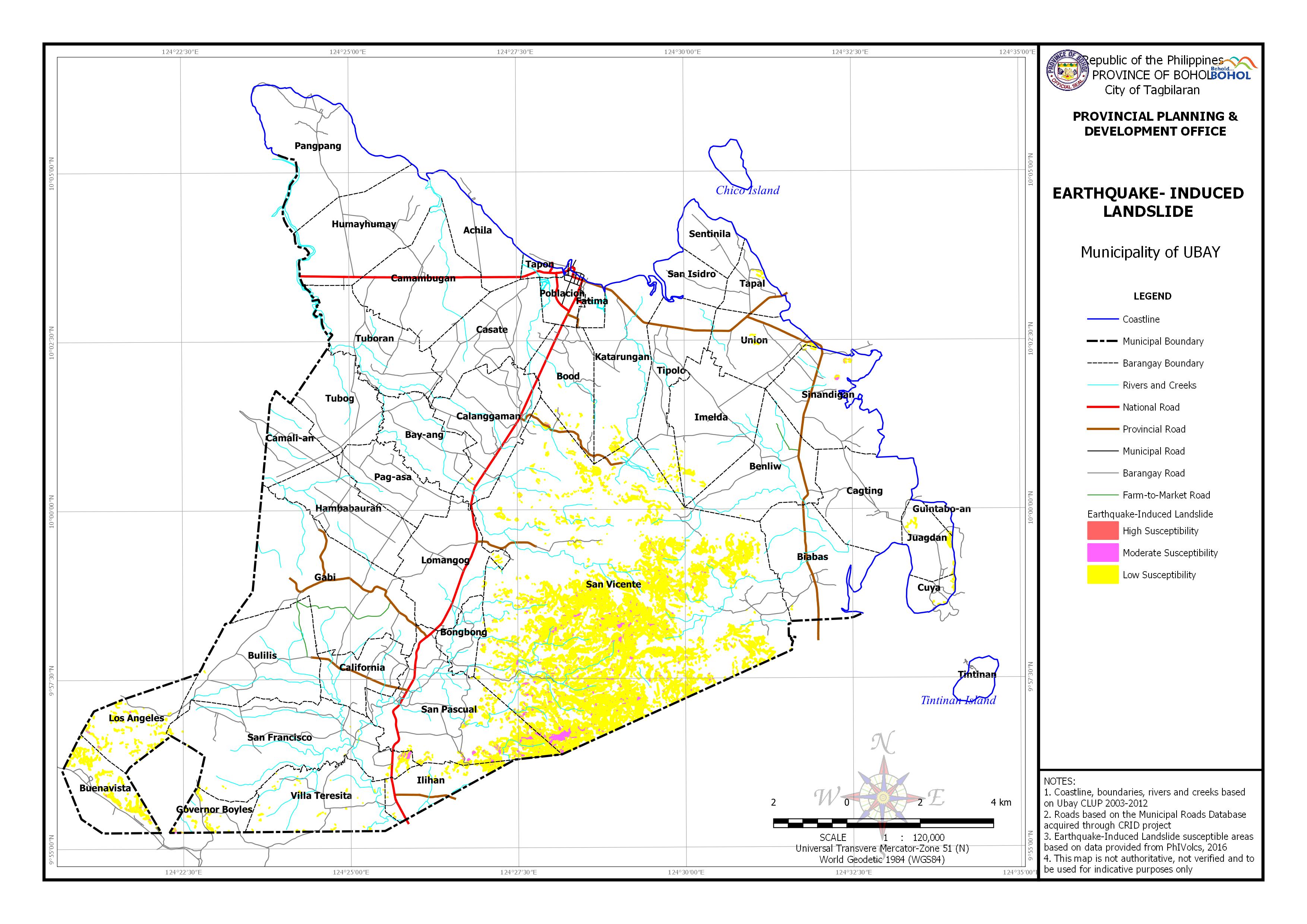
| Barangay | Area | Area Exposed to High Susceptibility | Area Exposed to Low Susceptibility | Area Exposed to Moderate Susceptibility | |||
| (Hectares) | (Hectares) | Percentage | (Hectares) | Percentage | (Hectares) | Percentage | |
| Benliw | 601.747 | 0.027 | 0.01% | ||||
| Biabas | 651.773 | 0.19 | 0.03% | ||||
| Bongbong | 171.884 | 0.131 | 0.08% | 0.04 | 0.02% | ||
| Bood | 416.584 | 1.667 | 0.40% | ||||
| Buenavista | 387.243 | 34.233 | 8.84% | 1.042 | 0.27% | ||
| Bulilis | 748.311 | 0.121 | 0.02% | ||||
| Cagting | 599.799 | 0.084 | 0.01% | ||||
| Calanggaman | 626.032 | 0.284 | 0.05% | ||||
| Cuya | 104.24 | 2.342 | 2.25% | 0.045 | 0.04% | ||
| Governor Boyles | 187.582 | 6.297 | 3.36% | 0.331 | 0.18% | ||
| Guintabo-an | 34.34 | 0.567 | 1.65% | ||||
| Ilihan | 276.9 | 12.404 | 4.48% | 0.883 | 0.32% | ||
| Imelda | 665.93 | 4.384 | 0.66% | ||||
| Juagdan | 229.23 | 4.983 | 2.17% | 0.05 | 0.02% | ||
| Katarungan | 662.961 | 4.642 | 0.70% | 0.253 | 0.04% | ||
| Lomangog | 619.483 | 1.252 | 0.20% | ||||
| Los Angeles | 402.969 | 18.141 | 4.50% | 0.803 | 0.20% | ||
| San Francisco | 1,124.52 | 7.781 | 0.69% | 1.908 | 0.17% | ||
| San Pascual | 995.168 | 0.067 | 0.01% | 76.198 | 7.66% | 17.527 | 1.76% |
| San Vicente | 5,232.85 | 959.762 | 18.34% | 102.972 | 1.97% | ||
| Sinandigan | 618.453 | 2.394 | 0.39% | 0.702 | 0.11% | ||
| Tapal | 204.493 | 1.228 | 0.60% | ||||
| Tipolo | 530.348 | 2.239 | 0.42% | ||||
| Union | 402.419 | 1.959 | 0.49% | 0.026 | 0.01% | ||
| Villa Teresita | 611.564 | 3.539 | 0.58% | ||||
| Total | 25,218.06 | 0.067 | 0.01% | 25,218.06 | 58.56% | 126.58 | 5.11% |