
Download in PDF and JPG format
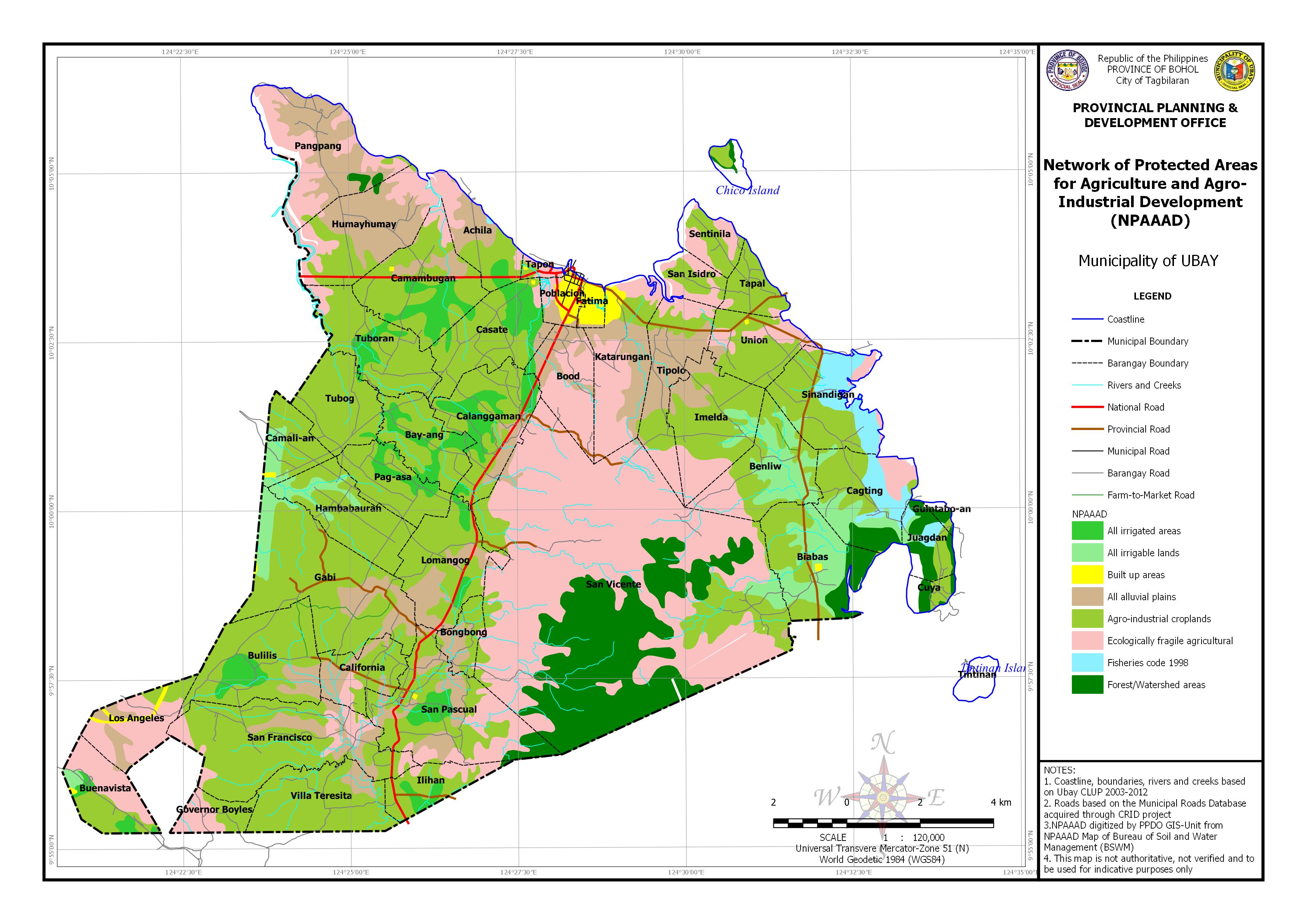
| Barangay | Area | Area Exposed to All alluvial plains | Area Exposed to Agro-industrial croplands | Area Exposed to Ecologically fragile agricultural | Area Exposed to Fisheries code 1998 | Area Exposed to Forest/Watershed areas | |||||
| (Hectares) | (Hectares) | Percentage | (Hectares) | Percentage | (Hectares) | Percentage | (Hectares) | Percentage | (Hectares) | Percentage | |
| Achila | 368.967 | 121.911 | 33.04% | 127.072 | 34.44% | 79.59 | 21.57% | 1.962 | 0.53% | ||
| Bay-ang | 415.145 | 278.198 | 67.01% | ||||||||
| Benliw | 601.747 | 209.311 | 34.78% | 114.571 | 19.04% | ||||||
| Biabas | 651.773 | 236.864 | 36.34% | 108.071 | 16.58% | ||||||
| Bongbong | 171.884 | 79.675 | 46.35% | 87.618 | 50.98% | 4.59 | 2.67% | ||||
| Bood | 416.584 | 137.909 | 33.11% | 0.085 | 0.02% | 267.08 | 64.11% | ||||
| Buenavista | 387.243 | 2.885 | 0.75% | 125.157 | 32.32% | 187.919 | 48.53% | ||||
| Bulilis | 748.311 | 83.966 | 11.22% | 559.058 | 74.71% | 2.205 | 0.30% | ||||
| Cagting | 599.799 | 194.51 | 32.43% | 78.472 | 13.08% | 104.747 | 17.46% | 72.098 | 12.02% | ||
| Calanggaman | 626.032 | 75.932 | 12.13% | 338.254 | 54.03% | 7.766 | 1.24% | ||||
| California | 326.555 | 113.215 | 34.67% | 182.484 | 55.88% | 30.856 | 9.45% | ||||
| Camali-an | 276.417 | 189.215 | 68.45% | ||||||||
| Camambugan | 719.742 | 88.156 | 12.25% | 429.077 | 59.62% | 37.37 | 5.19% | ||||
| Casate | 583.765 | 20.183 | 3.46% | 390.107 | 66.83% | 10.956 | 1.88% | ||||
| Cuya | 104.24 | 39.903 | 38.28% | 31.557 | 30.27% | ||||||
| Fatima | 79.998 | 6.398 | 8.00% | ||||||||
| Gabi | 1157.012 | 185.127 | 16.00% | 865.123 | 74.77% | ||||||
| Governor Boyles | 187.582 | 90.197 | 48.08% | 97.384 | 51.92% | ||||||
| Guintabo-an | 34.34 | 5.697 | 16.59% | 0.744 | 2.17% | 15.212 | 44.30% | ||||
| Hambabauran | 529.788 | 428.233 | 80.83% | ||||||||
| Humayhumay | 739.16 | 388.732 | 52.59% | 173.96 | 23.54% | 165.154 | 22.34% | 3.076 | 0.42% | ||
| Ilihan | 276.9 | 168.524 | 60.86% | 55.038 | 19.88% | 2.944 | 1.06% | ||||
| Imelda | 665.93 | 110.604 | 16.61% | 384.174 | 57.69% | 116.658 | 17.52% | ||||
| Juagdan | 229.23 | 55.311 | 24.13% | 41.25 | 18.00% | 91.047 | 39.72% | ||||
| Katarungan | 662.961 | 228.13 | 34.41% | 64.796 | 9.77% | 314.015 | 47.37% | ||||
| Lomangog | 619.483 | 168.109 | 27.14% | 378.825 | 61.15% | 19.5 | 3.15% | ||||
| Los Angeles | 402.969 | 75.121 | 18.64% | 53.232 | 13.21% | 235.299 | 58.39% | ||||
| Pag-asa | 384.338 | 298.829 | 77.75% | ||||||||
| Pangpang | 802.227 | 425.541 | 53.05% | 17.853 | 2.23% | 294.819 | 36.75% | 20.236 | 2.52% | ||
| Poblacion | 146.363 | 25.584 | 17.48% | 0.641 | 0.44% | 28.502 | 19.47% | ||||
| San Francisco | 1124.516 | 173.409 | 15.42% | 809.765 | 72.01% | 141.47 | 12.58% | ||||
| San Isidro | 196.71 | 90.843 | 46.18% | 83.094 | 42.24% | ||||||
| San Pascual | 995.168 | 218.588 | 21.97% | 410.696 | 41.27% | 220.135 | 22.12% | 57.318 | 5.76% | ||
| San Vicente | 5232.845 | 38.795 | 0.74% | 482.535 | 9.22% | 3163.923 | 60.46% | 1461.134 | 27.92% | ||
| Sentinila | 223.647 | 115.904 | 51.82% | 77.548 | 34.67% | ||||||
| Sinandigan | 618.453 | 347.512 | 56.19% | 43.918 | 7.10% | 204.394 | 33.05% | ||||
| Tapal | 204.493 | 191.659 | 93.72% | 12.834 | 6.28% | ||||||
| Tapon | 48.963 | 15.836 | 32.34% | 27.728 | 56.63% | ||||||
| Tintinan | 101.455 | ||||||||||
| Tipolo | 530.348 | 248.538 | 46.86% | 158.641 | 29.91% | 122.44 | 23.09% | ||||
| Tubog | 451.619 | 439.545 | 97.33% | ||||||||
| Tuboran | 559.37 | 452.446 | 80.89% | 27.916 | 4.99% | ||||||
| Union | 402.419 | 17.857 | 4.44% | 286.142 | 71.11% | 96.17 | 23.90% | ||||
| Villa Teresita | 611.564 | 54.535 | 8.92% | 557.03 | 91.08% | ||||||
| Total | 25218.055 | 3088.9 | 529.23% | 10730.862 | 2030.24% | 6164.92 | 757.90% | 353.097 | 71.21% | 1862.692 | 180.58% |