
Download in PDF and JPG format
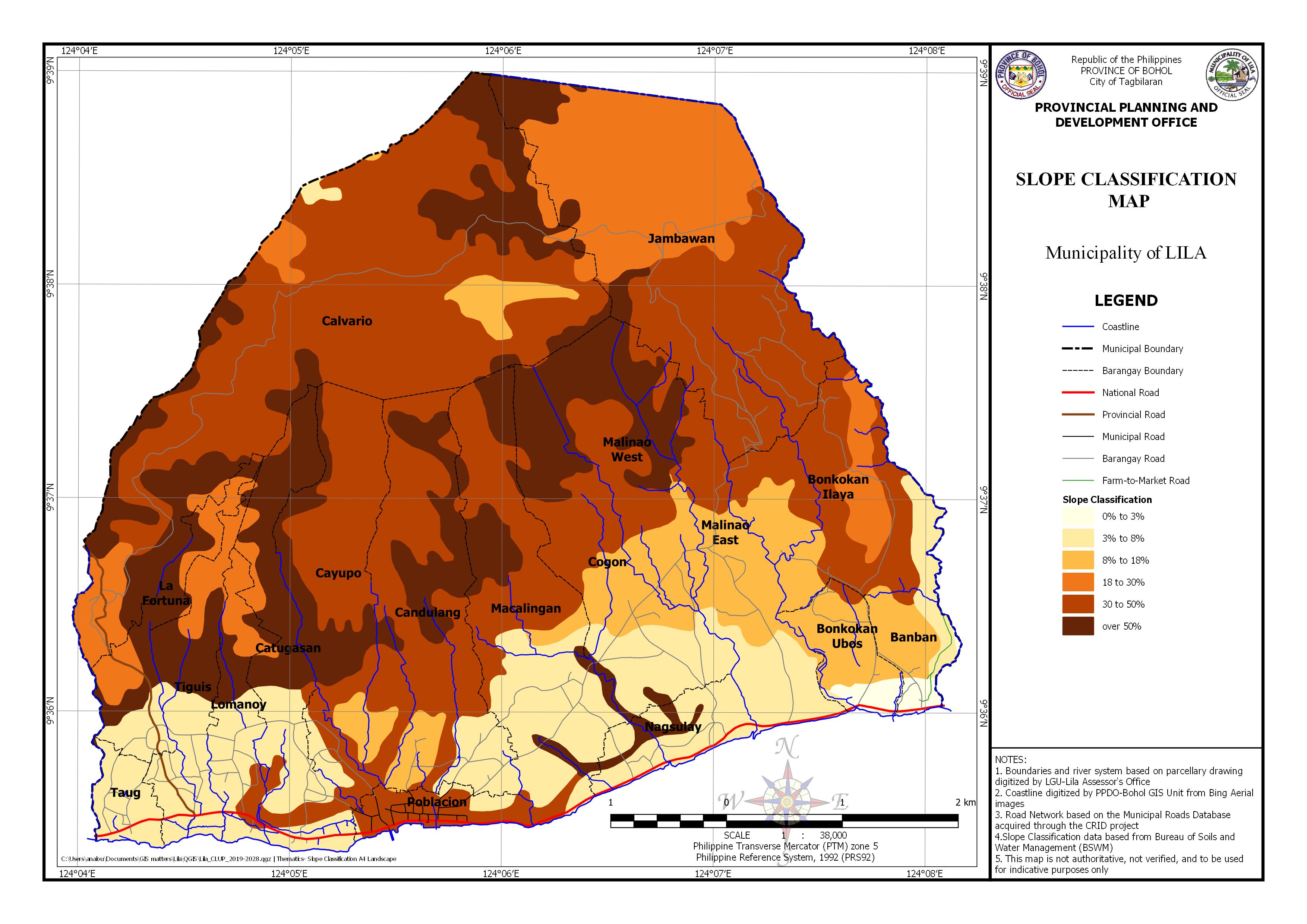
AREA EXPOSED TO SLOPE CLASSIFICATION BY BARANGAY
| Barangay | Area | 0 to 3% Slope | 3 to 8% Slope | 8 to 18% Slope | |||
|---|---|---|---|---|---|---|---|
| (Hectares) | (Hectares) | Percentage | (Hectares) | Percentage | (Hectares) | ( Percentage) | |
| Banban | 54.651 | 10.194 | 0.187 | 11.307 | 20.689% | 30.907 | 56.554% |
| Bonkokan Ilaya | 235.481 | 19.675 | 8.355% | 47.065 | 19.987% | ||
| Bonkokan Ubos | 66.327 | 12.638 | 0.191 | 1.955 | 2.947% | 48.105 | 72.527% |
| Calvario | 806.148 | 4.393 | 0.545% | 25.910 | 3.214% | ||
| Candulang | 293.490 | 33.862 | 11.538% | 28.116 | 9.580% | ||
| Catugasan | 171.121 | 60.487 | 35.348% | ||||
| Cayupo | 217.302 | 9.299 | 4.279% | 10.081 | 4.639% | ||
| Cogon | 207.025 | 63.728 | 30.783% | 41.295 | 19.947% | ||
| Jambawan | 499.561 | ||||||
| La Fortuna | 90.095 | 21.272 | 23.611% | ||||
| Lomanoy | 85.477 | 40.955 | 47.913% | ||||
| Macalingan | 283.497 | 105.322 | 37.151% | 7.803 | 2.753% | ||
| Malinao East | 194.783 | 55.479 | 28.483% | 65.149 | 33.447% | ||
| Malinao West | 150.937 | 41.245 | 27.326% | ||||
| Nagsulay | 70.907 | 58.188 | 82.062% | ||||
| Poblacion | 47.646 | 8.602 | 18.054% | 0.326 | 0.685% | ||
| Taug | 39.564 | 39.292 | 99.312% | ||||
| Tiguis | 119.020 | 59.281 | 49.807% | ||||
| Total | 3633.033 | 22.832 | 0.377 | 593.097 | 500.877% | 346.002 | 250.657% |
| Barangay | Area | 18 to 30% Slope | 30 to 50% Slope | Over 50% Slope | |||
|---|---|---|---|---|---|---|---|
| (Hectares) | Percentage | (Hectares) | Percentage | (Hectares) | Percentage | ||
| Banban | 54.651 | 2.243 | 4.104% | ||||
| Bonkokan Ilaya | 235.481 | 39.613 | 16.822% | 129.126 | 54.835% | ||
| Bonkokan Ubos | 66.327 | 3.630 | 5.473% | ||||
| Calvario | 806.148 | 61.303 | 7.604% | 514.906 | 63.872% | 199.640 | 24.765% |
| Candulang | 293.490 | 164.662 | 56.105% | 66.848 | 22.777% | ||
| Catugasan | 171.121 | 9.879 | 5.773% | 20.929 | 12.231% | 79.826 | 46.649% |
| Cayupo | 217.302 | 143.891 | 66.217% | 54.031 | 24.864% | ||
| Cogon | 207.025 | 51.225 | 24.743% | 50.778 | 24.527% | ||
| Jambawan | 499.561 | 231.621 | 46.365% | 230.753 | 46.191% | 37.205 | 7.447% |
| La Fortuna | 90.095 | 29.406 | 32.639% | 0.488 | 0.542% | 38.929 | 43.209% |
| Lomanoy | 85.477 | 18.032 | 21.096% | 9.273 | 10.848% | 17.218 | 20.143% |
| Macalingan | 283.497 | 110.824 | 39.092% | 59.547 | 21.005% | ||
| Malinao East | 194.783 | 39.566 | 20.313% | 34.588 | 17.757% | ||
| Malinao West | 150.937 | 51.829 | 34.338% | 57.863 | 38.336% | ||
| Nagsulay | 70.907 | 12.719 | 17.938% | ||||
| Poblacion | 47.646 | 38.718 | 81.261% | ||||
| Taug | 39.564 | 0.272 | 0.688% | ||||
| Tiguis | 119.020 | 22.521 | 18.922% | 0.007 | 0.006% | 37.212 | 31.265% |
| Total | 3633.033 | 412.373 | 149.220% | 1512.070 | 520.171% | 746.676 | 341.371% |