Skip to content
PPDO BOHOL
Provincial Planning and Development Office
Menu
Home
About
Citizen’s Charter
External Services
Internal Services
PPDC Page
Sectors
Special Unit
BIWRMT
Clean Water Act
Project Development Unit
Project Development Monitoring Unit (PDMU) personnel
Geographic Information System Unit
GIS Equipments
Geographic Information System (GIS) Unit Personnel
GIS Unit Tasks
ODA/Foreign Affairs Unit
Official Development Assistance Unit (ODA-IR) Personnel
Social Development Sector
Social Sector Personnel
Economic Development Sector
Economic Development Sector Personnel
Development Administration Sector
Development Administration Sector Personnel
Environment Management Sector
Environment Management Sector personnel
Infrastructure Development Sector
Infrastructure Development Sector Personnel
Administrative Division
Administrative Services
Printing and Photocopying Fees
Administrative Division Personnel
Administrative Reports
Profile
Socio Economic Profile
Environment and Natural Resource Management
Biodiversity Management
Natural Resource Management
Land Resource Management
Forestry
Water Resource Management
Mineral Resource Management
Coastal Resource Management
Urban Environment
Development Administration
Public Finance
Income Classification of the Province, City, and Municipalities
Internal Revenue Allotment (IRA) of Bohol LGUs (2011-2016)
Local Governance
Libraries and Reading Centers (2015)
Inventory of Sports / Recreational Facilities in the Province of Bohol
Local Special Bodies 2015
Civil Society Organization (CSO) Accreditation
Accredited CSOs 2022-2025
Accredited CSOs 2019-2022
Accredited CSOs 2016-2019
Accredited CSOs 2013-2016
Accredited CSOs 2010-2012
Justice and Safety
Fire Incidence & Protection Services
Fire-Fighting Force and Facilities (As of December 2015)
Fire Incidence – Province of Bohol (2012-2015)
Fire Incidents per Municipality/ City 2012-2015
Crime Statistics and Police Force
Crime Volume Bohol Province (2014-2017)
Jail Management
Rehabilitation and Detention Services (2015)
Rehabilitation and Detention Services (2014)
Judiciary Services
Infrastructure Development
Transport and Access
Roads and Bridges
Seaport
Airport
Land Transportation Office (LTO)
Water and Irrigation
Water and Irrigation
Power and Energy
Power and Energy 2023
Communication
Economic Development
Trade and Industry
Number, Area and Description of Markets by Municipality
Agriculture
Crops
Palay and Corn
Commercial Crops
Vegetables
Fruits
Root Crops
Ornamentals
Livestock
Fisheries
Commercial Fisheries
Inland Municipal Fisheries
Marine Municipal Fisheries
Aquaculture
Tourism
Visitor Arrivals
Tourist Attractions
Social Development
Health & Nutrition
Social Welfare
Education
Culture & Arts
Housing
Bohol Poverty Profile
Poverty Database Monitoring System (PDMS)
Bohol Quick Profile
Location Map
Fast Facts about Bohol
Provincial Symbols
Bohol An Area Profile
Provincial Capital/Administrative Units
Population & Human Development
Location & Accessibility
History/Language/Climate
Geographical and Resource Endowment
Socio-economic Situationer
Infrastructure
The Economy & Agricultural Productivity
Investments
Tourism
Social Services, Amenities & Development
Bohol’s Development Potentials
Bohol’s Development Challenges
Bohol’s Development Path
Overall Development Framework
The Bohol Poverty Framework
Development Directions & Policies
Major Breakthroughs/Local Initiatives
Municipalities
1st District
Tagbilaran
Alburquerque
Antequera
Baclayon
Balilihan
Calape
Catigbian
Corella
Dauis
Cortes
Loon
Maribojoc
Panglao
Sikatuna
Tubigon
2nd District
Bien Unido
Buenavista
Clarin
Dagohoy
Danao
Inabanga
Getafe
Pres. Carlos P. Garcia
Sagbayan
San Isidro
San Miguel
Talibon
Trinidad
Ubay
3rd District
Alicia
Anda
Batuan
Bilar
Candijay
Carmen
Dimiao
Duero
Garcia Hernandez
Guindulman
Loboc
Jagna
Lila
Mabini
Pilar
Sevilla
Sierra Bullones
Valencia
Loay
Projects
Bohol Energy Development Advisory Group (BEDAG)
BEDAG Technical Bulletin
BEDAG Technical Bulletin No. 1-2015
BEDAG Technical Bulletin No. 2-2015
PDC Matters
PDC Resolutions Series of 2017
PDC Resolutions Series of 2018
PDC Resolutions Series of 2019
PDC Resolutions Series of 2020
PDC Resolutions Series of 2021
PDC Resolutions Series of 2022
PDC Resolutions Series of 2023
PDC Resolutions Series of 2024
Provincial Atlas
Basic Maps
Bohol Base Map
Location Map
Bohol Districts Map
Development Maps
Development Constraints
Land Use Map
Development Opportunities Map
Facilities Maps
Road Network
Road Surface Type Map
PRMF Rehabilitation Map
Road Network Map
Road Management Unit
Road Condition Map
Traffic Count Map
Shapefiles
Base Map Shapefiles
Hazards
Thematics
Municipal Maps
1st District
Alburquerque
Base Map
Hazard Maps
Earthquake-Induced Landslide
Flooding
Ground shaking
Liquefaction
Rain-Induced landslide
Storm Surge
Tsunami
Statistical Maps
Annual Growth Rate
Population Change
Population Density
Population Distribution
Thematic Maps
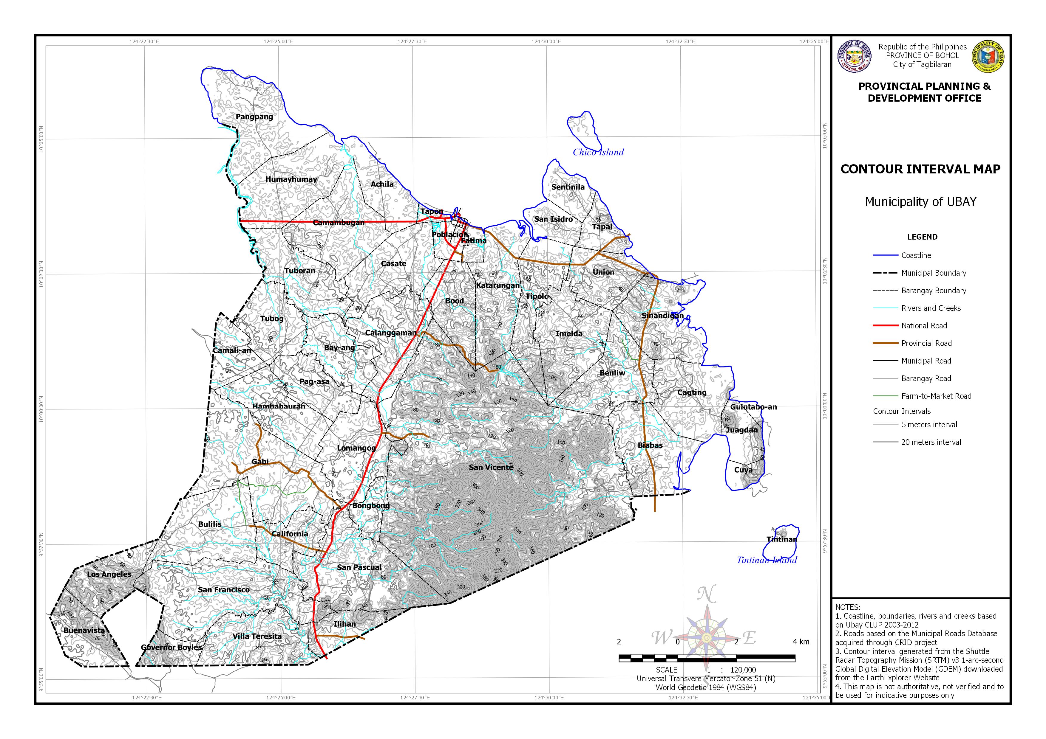
Contour Interval Map
Elevation Range
Geologic Formation
Land Classification
Land Cover
Network of Protected Areas for Agriculture and Agro-Industrial Development (NPAAAD)
Slope
Soil Classification
Antequera
Basic Maps
Hazard Maps
Statistical Maps
Thematic Maps
Baclayon
Basic Maps
Hazard Maps
Statistical Maps
Thematic Maps
Balilihan
Basic Maps
Hazard Maps
Statistical Maps
Thematic Maps
Calape
Basic Maps
Hazard Maps
Statistical Maps
Thematic Maps
Catigbian
Basic Maps
Base Map
Location Map
Hazard Maps
Earthquake-Induced Landslide
Flooding
Ground Shaking
Rain-Induced Landslide
Statistical Maps
Population Density
Projected Population Density
Population Growth Rate
Population Temporal Change
Population Distribution
Thematic Maps
Land Classification
Geologic Formation
Land Cover
Slope
Soil
Watershed
Corella
Basic Maps
Hazard Maps
Statistical Maps
Thematic Maps
Cortes
Basic Maps
Hazard Maps
Statistical Maps
Thematic Maps
Dauis
Base Map
Hazard Maps
Earthquake-Induced Landslide
Flooding
Liquefaction
Rain-Induced Landslide
Storm Surge
Tsunami
Statistical Maps
Population Distribution
Population Density
Population Change
Annual Growth Rate
Thematic Maps
Geological Formation
Land Classification Map
Network of Protected Areas for Agriculture and Agro-Industrial Map (NPAAAD)
Slope Classification Map
Soil Classification Map
Land Cover
Network of Protected Areas for Agriculture and Agro-Industrial Development (NPAAAD)
Loon
Basic Maps
Base Map
Hazard Maps
Earthquake-Induced Landslide
Faultlines
Flooding
Ground Shaking
Statistical Maps
Thematic Maps
Maribojoc
Basic Maps
Hazard Maps
Statistical Maps
Thematic Maps
Panglao
Basic Maps
Hazard Maps
Statistical Maps
Thematic Maps
Tagbilaran
Basic Maps
Hazard Maps
Statistical Maps
Thematic Maps
2nd District
Clarin
Basic Maps
Hazard Maps
Statistical Maps
Thematic Maps
Getafe
Basic Maps
Hazard Maps
Statistical Maps
Thematic Maps
Dagohoy
Basic Maps
Hazard Maps
Statistical Maps
Thematic Maps
Sagbayan
Basic Maps
Hazard Maps
Statistical Maps
Thematic Maps
San Miguel
Basic Maps
Base Map
Hazard Maps
Earthquake-Induced Landslide
Flooding
Liquefaction
Rain-Induced Landslide
Statistical Maps
Annual Growth Rate
Population Change
Population Density
Population Distribution
Thematic Maps
Geologic
Land Classification
Land Cover
Relief and Drainage
Slope
Soil
Watershed
Trinidad
Basic Maps
Base Map
Hazard Maps
Earthquake-Induced Landslide Map
Flooding
Ground Shaking
Liquefaction
Rain-Induced Landslide
Tsunami
Statistical Maps
Annual Growth Rate
Population Temporal Change
Population Density
Population Distribution
Thematic Maps
Geologic
Land Classification
Land Cover
Network of Protected Areas for Agriculture and Agro-Industrial Development (NPAAAD)
Relief and Drainage
Ubay
Basic Maps
Basemap
Hazard Maps
Earthquake-Induced Landslide
Flooding
Liquefaction
Rain-Induced Landslide
Storm Surge
Tsunami
Statistical Maps
Annual Growth Rate
Population Distribution
Population Change
Population Density Map
Thematic Maps
Contour Interval
Elevation Range
Land Classification
Land Cover
Network of Protected Areas for Agriculture and Agro-Industrial Development (NPAAAD)
Slope Map
Watershed
Geological
3rd District
Alicia
Basic Maps
Base Map
Hazard Maps
Flooding
Ground Shaking
Liquefaction
Rain-Induced Landslide
Earthquake-Induced Landslide
Statistical Maps
Annual Growth Rate
Population Distribution
Population Density
Population Change
Thematic Maps
Elevation Range
Geological Formation
Land Classification
Land Cover
Network of Protected Areas for Agriculture and Agro-Industrial Development (NPAAAD)
Slope
Soil Classification
Watershed
Anda
Basic Maps
Base Map
Hazard Maps
Earthquake-Induced Landslide
Flooding
Ground Shaking
Liquefaction
Rain-Induced Landslide
Storm Surge
Tsunami
Statistical Maps
Annual Growth Rate
Population Distribution
Population Change
Population Density
Thematic Maps
Contour Interval
Elevation Range
Geological
Land Classification
Land Cover
Network of Protected Areas for Agriculture and Agro-Industrial Development (NPAAAD)
Slope
Soil Classification
Batuan
Basic Maps
Base Map
Hazard Maps
Earthquake-Induced Landslide
Flooding
Ground Shaking
Liquefaction
Rain-Induced Landslide Map
Statistical Maps
Annual Growth Rate
Population Change
Population Density
Population Distribution
Thematic Maps
Elevation Range
Geologic
Land Classification
Land Cover
Network of Protected Areas for Agriculture and Agro-Industrial Development (NPAAAD)
Slope
Soil Classification
Watershed
Candijay
Basic Maps
Base Map
Hazard Maps
Earthquake-Induced Landslide
Flooding
Liquefaction
Rain-Induced Landslide
Storm Surge
Tsunami
Statistical Maps
Annual Growth Rate
Population Temporal Change
Population Density
Population Distribution
Thematic Maps
Geologic
Land Classification
Land Cover
Network of Protected Areas for Agriculture and Agro-Industrial Development (NPAAAD)
Relief and Drainage
Slope
Soil
Watershed
Carmen
Basic Maps
Hazard Maps
Statistical Maps
Thematic Maps
Dimiao
Basic Maps
Hazard Maps
Statistical Maps
Thematic Maps
Duero
Basic Maps
Hazard Maps
Statistical Maps
Thematic Maps
Guindulman
Basic Maps
Base Map
Hazard Maps
Earthquake-Induced Landslide
Flooding
Ground Shaking
Liquefaction
Rain-Induced Landslide
Storm Surge
Tsunami
Statistical Maps
Annual Growth Rate
Population Change
Population Density
Population Distribution
Thematic Maps
Contour
Geologic
Land Classification
Land Cover
Network of Protected Areas for Agriculture and Agro-Industrial Development (NPAAAD)
Relief and Drainage
Slope
Soil
Watersheds
Lila
Basic Maps
Base Map
Hazard Maps
Earthquake-Induced Landslide
Flooding
Ground Rupture
Ground Shaking
Liquefaction
Rain-Induced Landslide
Storm Suge
Tsunami
Statistical Maps
Annual Growth Rate
Population Distribution
Population Density
Population Change
Projected Population Density
Projected Population
Thematic Maps
Elevation Range
Watershed Delineation
Soil Classification
Slope Classification
Network of Protected Areas from Agriculture and Agro-Industrial Development (NPAAAD)
Landcover
Land Classification
Geological Formation
Contours
Loboc
Basic Maps
Basemap
Location Map
Hazard Maps
Earthquake-Induced Landslide
Flooding
Ground Shaking
Liquefaction
Rain-Induced Landslide
Tsunami
Multi-Hazard
Statistical Maps
Population Distribution
Population Change
Population Density
Population Growth Rate
Thematic Maps
Contours
Geologic
Land Classification
Land Cover
Network of Protected Areas for Agriculture and Agro-Industrial Development (NPAAAD)
Relief and Drainage
Slope
Soil
Watersheds
Mabini
Basic Maps
Base Map
Hazard Maps
Earthquake-Induced Landslide
Flooding
Ground Shaking
Liquefaction
Rain-Induced Landslide
Storm Surge
Tsunami
Statistical Maps
Annual Growth Rate
Population Change
Population Density
Population Distribution
Thematic Maps
Contour
Geologic
Land Classification
Land Cover
Network of Protected Areas for Agriculture and Agro-Industrial Development (NPAAAD)
Relief & Drainage
Slope
Soil
Watershed
Sevilla
Basic Maps
Hazard Maps
Statistical Maps
Thematic Maps
Sierra Bullones
Basic Maps
Hazard Maps
Statistical Maps
Thematic Maps
Valencia
Basic Maps
Hazard Maps
Statistical Maps
Thematic Maps
Hazard Maps
Earthquake-Induced Landslide
Alburquerque
Alicia
Anda
Antequera
Baclayon
Balilihan
Batuan
Bilar
Buenavista
Calape
Candijay
Carmen
Catigbian
Clarin
Corella
Cortes
Dagohoy
Danao
Dauis
Dimiao
Duero
Garcia-Hernandez
Getafe
Guindulman
Inabanga
Jagna
Lila
Loay
Loboc
Loon
Mabini
Maribojoc
Panglao
Pilar
Pres. Carlos P. Garcia
Sagbayan
San Isidro
San Miguel
Sevilla
Sierra Bullones
Sikatuna
Tagbilaran City
Talibon
Trinidad
Tubigon
Ubay
Valencia
Ground Rupture
Carmen
Dimiao
Lila
Loay
Pilar
Sierra Bullones
Valencia
Ground Shaking
Alburquerque
Alicia
Anda
Antequera
Baclayon
Balilihan
Batuan
Bien Unido
Bilar
Buenavista
Calape
Candijay
Carmen
Catigbian
Clarin
Corella
Cortes
Dagohoy
Danao
Dauis
Dimiao
Duero
Garcia Hernandez
Getafe
Guindulman
Inabanga
Jagna
Lila
Loay
Loboc
Loon
Mabini
Maribojoc
Panglao
Pilar
President Garcia
Sagbayan
San Isidro
San Miguel
Sevilla
Sierra Bullones
Sikatuna
Tagbilaran City
Talibon
Trinidad
Tubigon
Ubay
Valencia
Liquefaction
Alburquerue
Alicia
Anda
Baclayon
Batuan
Bilar
Bien Unido
Buenavista
Calape
Carmen
Clarin
Cortes
Dagohoy
Danao
Dauis
Dimiao
Duero
Garcia Hernandez
Getafe
Guindulman
Inabanga
Jagna
Lila
Loay
Loboc
Mabini
Maribojoc
Panglao
President Garcia
San Miguel
Tagbilaran
Talibon
Trinidad
Ubay
Valencia
Candijay
Rain-Induced Landslide
Alburquerque
Alicia
Anda
Antequera
Baclayon
Balilihan
Batuan
Bien Unido
Bilar
Buenavista
Calape
Candijay
Carmen
Catigbian
Clarin
Corella
Cortes
Dagohoy
Danao
Dauis
Dimiao
Duero
Garcia Hernandez
Getafe
Guindulman
Inabanga
Jagna
Lila
Loay
Loboc
Loon
Mabini
Maribojoc
Panglao
Pilar
Pres. Carlos P. Garcia
Sagbayan
San Isidro
San Miguel
Sevilla
Sierra Bullones
Sikatuna
Tagbilaran
Talibon
Trinidad
Tubigon
Ubay
Valencia
Storm Surge
Alburquerque
Anda
Baclayon
Bien Unido
Buenavista
Calape
Candijay
Clarin
Cortes
Dauis
Dimiao
Duero
Garcia Hernandez
Guindulman
Inabanga
Jagna
Lila
Loay
Loon
Mabini
Maribojoc
Panglao
President Garcia
Tagbilaran
Talibon
Tubigon
Ubay
Valencia
Tsunami
Alburquerque
Anda
Baclayon
Bien Unido
Buenavista
Calape
Candijay
Clarin
Cortes
Dauis
Dimiao
Duero
Garcia Hernandez
Getafe
Guindulman
Inabanga
Jagna
Lila
Loay
Loboc
Loon
Mabini
Maribojoc
Panglao
Pres. Carlos P. Garcia
Sikatuna
Tagbilaran
Talibon
Statistical Maps
NSCB Based Maps
NSCB Poverty Incidence 2003
NSCB Poverty Incidence 2005
NSCB Poverty Incidence 2009
NSCB Poverty Incidence 2012
NSO Based Maps
Population Distribution 1990
Population Distribution 2000
Population Distribution 2007
Population Change 2000-2007
Population Projection 2015
Population Distribution 2010
PDMS Based Maps
Child Malnutrition
Anda
Antequera
Batuan
Bien Unido
Calape
Catigbian
Cortes
Carmen
Corella
Danao
Dauis
Dimiao
Guindulman
Alburquerque
Alicia
Candijay
Child Mortality
Alburquerque
Alicia
Anda
Antequera
Batuan
Calape
Carmen
Catigbian
Corella
Cortes
Danao
Dauis
Dimiao
Guindulman
Candijay
Crime Incidence
Alburquerque
Alicia
Anda
Antequera
Batuan
Calape
Carmen
Catigbian
Corella
Cortes
Danao
Dauis
Dimiao
Guindulman
Candijay
Food Threshold
Alburquerque
Alicia
Anda
Antequera
Batuan
Calape
Carmen
Catigbian
Corella
Cortes
Danao
Dauis
Dimiao
Guindulman
Candijay
Makeshift/Temporary Housing
Alburquerque
Alicia
Anda
Antequera
Batuan
Calape
Candijay
Carmen
Catigbian
Corella
Cortes
Danao
Dauis
Dimiao
Guindulman
Income Threshold
Alburquerque
Alicia
Anda
Antequera
Batuan
Calape
Candijay
Carmen
Catigbian
Corella
Cortes
Danao
Dauis
Dimiao
Guindulman
Meals Threshold
Alburquerque
Alicia
Anda
Antequera
Batuan
Calape
Candijay
Carmen
Catigbian
Corella
Cortes
Danao
Dauis
Dimiao
Guindulman
Sanitation Indicator
Alburquerque
Alicia
Antequera
Batuan
Calape
Candijay
Carmen
Catigbian
Anda
Corella
Cortes
Danao
Dauis
Dimiao
Guindulman
School Dropouts
Alburquerque
Alicia
Anda
Antequera
Batuan
Calape
Candijay
Carmen
Catigbian
Corella
Cortes
Dimiao
Danao
Dauis
Guindulman
Households not Owning the Lot
Alburquerque
Alicia
Anda
Antequera
Batuan
Calape
Carmen
Candijay
Catigbian
Corella
Cortes
Danao
Dauis
Dimiao
Guindulman
Unemployed Persons
Alburquerque
Alicia
Anda
Antequera
Batuan
Calape
Candijay
Carmen
Corella
Cortes
Danao
Dauis
Dimiao
Guindulman
Water Indicator
Alburquerque
Alicia
Anda
Antequera
Batuan
Calape
Candijay
Carmen
Catigbian
Corella
Cortes
Danao
Dauis
Dimiao
Guindulman
Averaged Deprivation
Alburquerque
Alicia
Anda
Antequera
Batuan
Bien Unido
Calape
Carmen
Catigbian
Corella
Cortes
Danao
Dauis
Guindulman
Dimiao
Candijay
Thematic Maps
Geologic Map
Relief and Drainage Map
Topographic Map
Land Classification Map
NPAAAD Map
Slope Map
Soil Map
Land Use / Vegetation Map
Watershed Map
Plans & Reports
Monitoring and Evaluation
2011 PRNDP M&E Report
2011 SFMP M&E Report
2011 ELA M&E Report
2011 HRMDP M&E Report
Annual Monitoring Report
M&E Report 2022
Disaster Risk Reduction and Management
We Survive As One Bohol Program
Bohol Post-Odette Rehabilitation and Recovery Plan 2022
Provincial Disaster Risk Reduction Management Plan (PDRRMP) 2014 – 2016
Provincial Disaster Risk Reduction and Management Plan (PDRRMP) 2017-2019
Provincial Disaster Risk Reduction and Management Plan (PDRRMP) 2020-2022
Provincial Disaster Risk Reduction and Management Plan (PDRRMP) 2023-2025
Devolution Transition Plan
Devolution Transition Plan (DTP) 2022-2024
Development Plans
Integrated Transport Plan Framework 2013-2020
Provincial Development Investment Program (PDIP) 2011-2015
2013 Earthquake Rehabilitation Plan
Bohol Island Power Development Plan (BIPDP)
Provincial Governance Reform Roadmap (PGRR)
Provincial Commodity Investment Plan (PCIP)
Local Road Network Development Plan (LRNDP)
PRNDP 2009-2014
PRNDP 2011-2015
LRNDP 2018-2022
LRNDP 2021-2025
Master Plan Study of Bohol Integrated Area Development (BIAD) Project
Annual Investment Program (AIP)
Biodiversity Conservation and Eco-Tourism Framework Plan of Bohol 2006 – 2015
Bohol Agriculture Master Plan (BAMP) 2006-2026
Bohol Integrated Water Supply System Master Plan (BIWSSMP) 2010-2035
Executive-Legislative Agenda (ELA)
Human Resource Management and Development Plan (HRMDP) 2011-2015
Provincial Development & Physical Framework Plan (PDPFP)
Provincial Water Supply, Sewerage and Sanitation Sector Plan (PW4SP) 2004-2013
Strategic Financial Management Plan 2011-2015
Tourism Master Plan
Environmental Assessment Report
EAR – Rehab Mahayag-Katipunan Road (Alicia Side), Alicia, Bohol
EAR Rehab – Pob. Valencia-Anoyon-Omjon Road, Valencia, Bohol
Provincial Annual Reports
State of the Province Address (SOPA)
Annual Report 2005
Annual Report 2006
Annual Report 2007
Annual Report 2008
Annual Report 2009
Annual Report 2010
Annual Report 2011
Annual Report 2012
Annual Report 2013
Annual Report 2014
Annual Report 2015
Annual Report 2016
Annual Report 2017
Annual Report 2018
Annual Report 2019
Annual Report 2020
Annual Report 2021
Annual Report 2022
Annual Report 2023
Annual Report 2024
Events
Bohol Prosperity Fair
Bohol Prosperity Fair 2010
Prosperity Fair BIAD Project Proposals
Bohol Poverty Fair 2006
Bohol Poverty Fair 2007
Bohol Poverty Fair 2008
News
Contact Us
Contour Interval
Download in
PDF
and
JPG
format
Leave a Comment
Cancel reply
Comment
Name
Email
Website