Download in PDF or in JPG formats
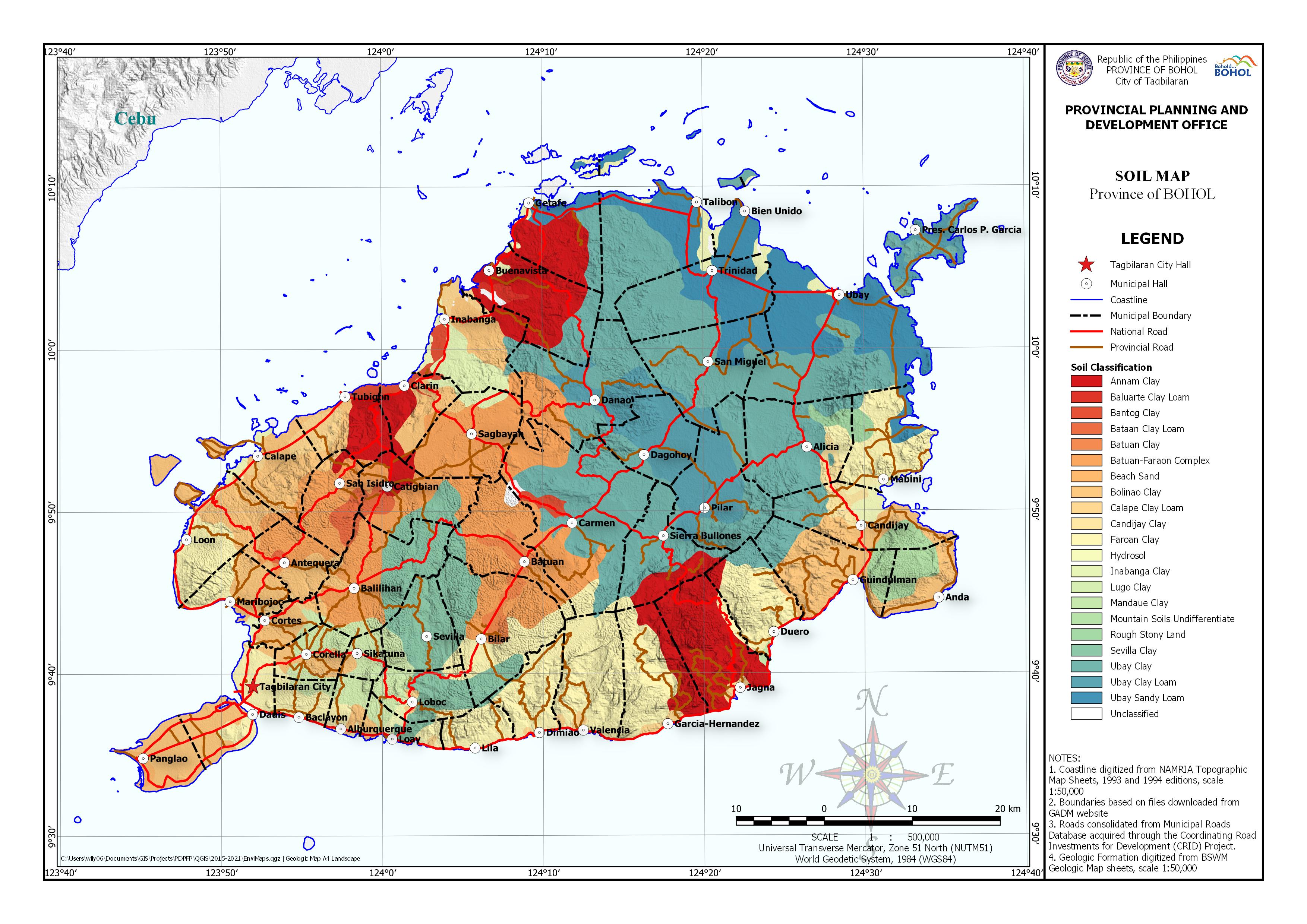
The Soil Map shows areas of different soil classification categorized as follows: Annam Clay, Baluarte Clay Loam, Bantog Clay, Bataan Clay Loam, Batuan Clay, Batuan-Faraon Complex, Beach Sand, Bolinao Clay, Calape Clay Loam, Candijay Clay, Faraon Clay, Hydrosol, Inabanga Clay, Lugo Clay, Mandaue Clay, Mountain Soil Undifferentiate, Rough Stony Land, Sevilla Clay, Ubay Clay, Ubay Clay Loam and, Ubay Sandy Loam. The Soil features were digitized from the Soil Map of the Bureau of Soil and Water Management. Base map features were digitized from the National Mapping and Resource Information Authority (NAMRIA) Topographic Map sheets scaled at 1:50,000 using heads-up digitizing method.
Available in PDF and JPG formats, this map may be downloaded and used for free provided that no alterations are made to the map and that proper citations be referred to this source.


do you know how much does is for sale in the province of bohol?
Hi Anatoliv. I’m not sure what you mean, but if you mean maps for sale, the PPDO-Bohol has no maps for sale. We share them through this website so our clients can download for free.
SIr,, can i ask if you have already the latest topographic map and Geohazard , land use and vegetation ma, soil map and lqand condition map of Bohol Province?
we need this for our thesis proposal study ,.. and if ever all of this above mentioned are available we are willing to pay. we are from University of the Visayas student and we propose an agri-ecotourism development in between Inabanga, Buenavista and Danao Bohol
I’m not sure of “lqand condition map” but pretty much of what you mentioned is here in this section. The maps here is still our current versions. I’ll try to remember to notify you when updates are uploaded.
Sir, may i ask if you have information or details regarding each soil classification such as soil description, soil properties, features, bearing capacity, etc.? Thanks!
Hello Cid,
We’re sorry but the information indicated in the map is also what’s on our sources. You may want to contact the Bureau of Soil and Water Management. They should be the ones in authority of the information you need. Thank you for your consideration.
hello sir. is sandy loam only found in ubay? is there none in tagbilaran or anywhere near to the area? thank you sir 🙂
Seems like it
Good day! Kindly consider updating your maps (geologic, soil, etc.). I’m not sure if others think the same but I could hardly identify which is which in the legend because of the color scheme. Thank you!
We agree and updated the maps. Hopefully, the update satisfies your needs.
May I ask po what are the source of fresh waters in Bohol specifically? Also, what are the minerals that can be found in Bohol?
Hi Jay, thank you for your comment. Perhaps you can find information from the Provincial Development and Physical Framework Plan (PDPFP)
Hello, may I ask about the specific gravity of each type of soil sir?
Hi Prescila, please refer to the PDPFP 2016-2028 page 25.
Which among those soils are acidic and alkaline?
Hi Kyle, thank you for your interest of the Province of Bohol. The Soil Map data was digitized from the Soil Map of the Bureau of Soils and Water Management (BSWM). For that, we are recommending to refer your concern to the data source for the interpretation of the data. Once again, thank you.
Hello po, may I ask po if anong unit ung ginamit ninyo po sa area ng soil classification map. Thank you po
Hi Ms. Pam, we’re not sure what unit you’re referring to. We can only find in the map, figures of the graticules in latitude and longitude.