
Download in PDF and JPG format
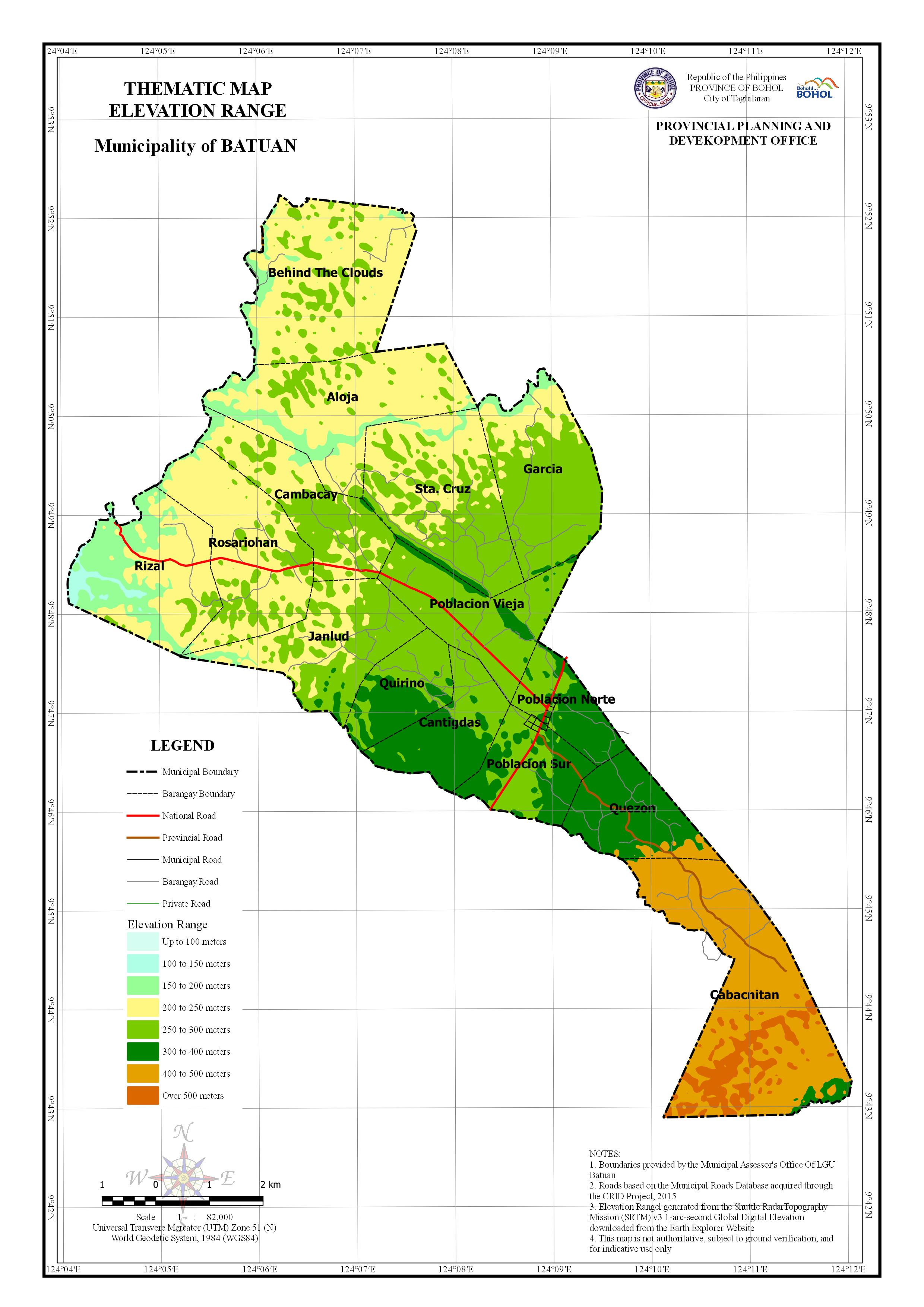
AREA PER ELEVATION RANGE BY BARANGAY
| Barangay | Area | 100 to 150 meters | 150 to 200 meters | 200 to 250 meters | 250 to 300 meters | 300 to 400 meters | 400 to 500 meters | Over 500 meters | |||||||
| (Hectares) | (Hectares) | Percentage | (Hectares) | Percentage | (Hectares) | Percentage | (Hectares) | Percentage | (Hectares) | Percentage | (Hectares) | Percentage | (Hectares) | Percentage | |
| Aloja | 703.38 | 15.044 | 2.139% | 124.295 | 17.671% | ||||||||||
| Behind The Clouds | 777.08 | 325.979 | 41.949% | 864.819 | 111.291% | ||||||||||
| Cabacnitan | 1009.193 | 1491.063 | 147.748% | 54.001 | 5.351% | ||||||||||
| Cambacay | 434.135 | 504.985 | 116.320% | ||||||||||||
| Cantigdas | 326.134 | 507.401 | 155.581% | ||||||||||||
| Garcia | 565.007 | 417.457 | 73.885% | ||||||||||||
| Janlud | 506.905 | 516.209 | 101.835% | ||||||||||||
| Poblacion Norte | 224.341 | 159.916 | 71.283% | ||||||||||||
| Poblacion Sur | 317.725 | 392.953 | 123.677% | ||||||||||||
| Poblacion Vieja | 447.363 | 183.242 | 40.960% | 181.393 | 40.547% | ||||||||||
| Quezon | 344.134 | 304.397 | 88.453% | ||||||||||||
| Quirino | 269.747 | 265.673 | 98.490% | ||||||||||||
| Rizal | 583.21 | 347.061 | 59.509% | ||||||||||||
| Rosariohan | 588.702 | 87.12 | 14.799% | 574.843 | 97.646% | ||||||||||
| Sta. Cruz | 676.062 | 274.337 | 40.579% | 180.938 | 26.764% | ||||||||||
| Total | 7773.119 | 15.044 | 0.194% | 450.274 | 5.793% | 2355.882 | 30.308% | 2736.163 | 35.200% | 1185.645 | 15.253% | 849.18 | 10.925% | 180.938 | 2.328% |