
Download in PDF and JPG format
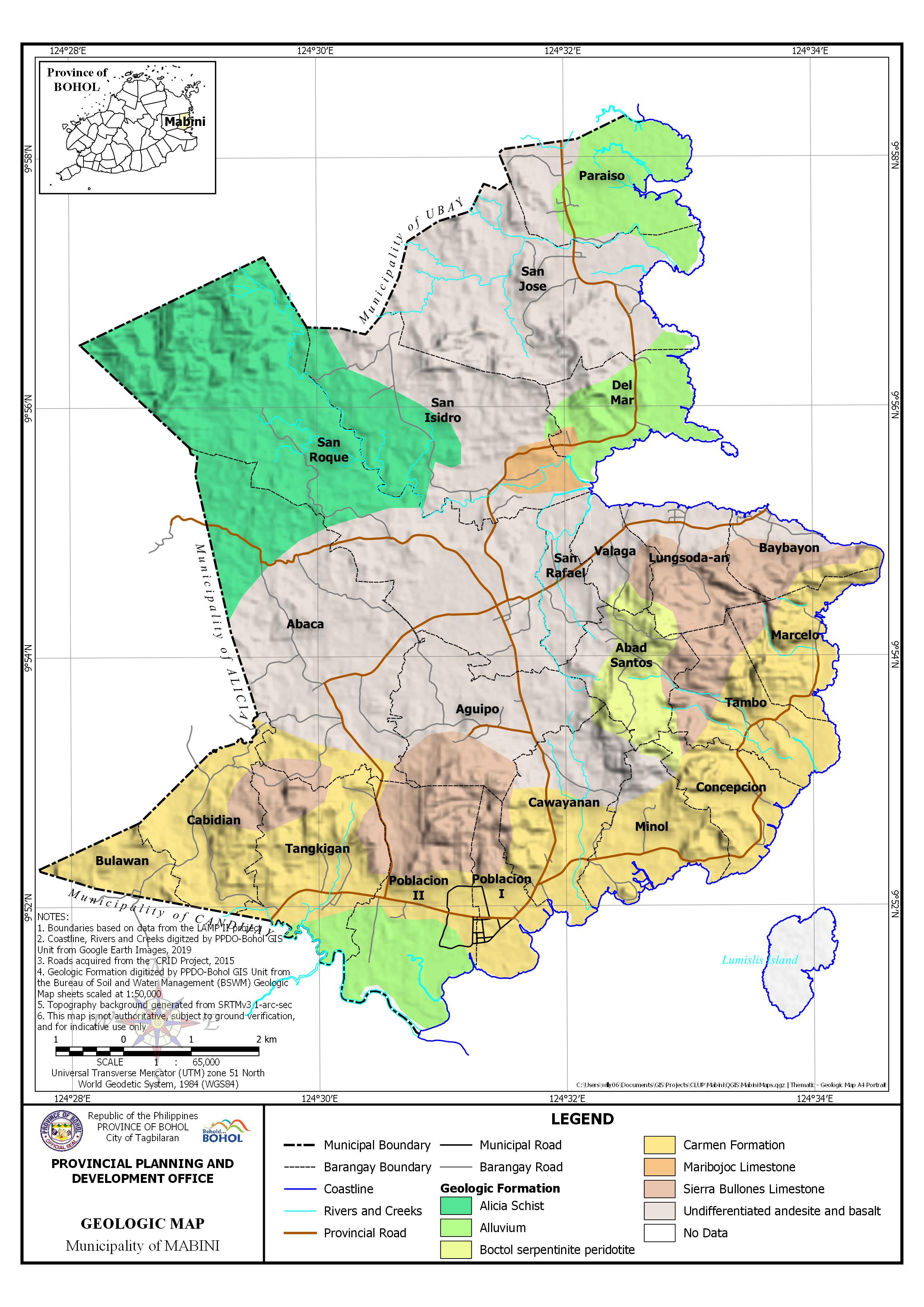
AREA PER GEOLOGIC FORMATION BY BARANGAY
| Barangay | Area | Alicia Schist | Alluvium | Boctol serpentinite peridotite | Carmen Formation | Maribojoc Limestone | Sierra Bullones Limestone | Undifferentiated andesite and basalt lava flows | No Data | ||||||||
| Hectares | Hectares | Percentage | Hectares | Percentage | Hectares | Percentage | Hectares | Percentage | Hectares | Percentage | Hectares | Percentage | Hectares | Percentage | Hectares | Percentage | |
| Abaca | 944.471 | 224.067 | 23.72% | 62.1 | 6.58% | 33.625 | 3.56% | 624.679 | 66.14% | ||||||||
| Abad Santos | 232.914 | 160.59 | 68.95% | 25.251 | 10.84% | 47.073 | 20.21% | ||||||||||
| Aguipo | 442.045 | 3.823 | 0.87% | 111.086 | 25.13% | 327.135 | 74.01% | ||||||||||
| Baybayon | 185.445 | 30.658 | 16.53% | 102.766 | 55.42% | 49.729 | 26.82% | 2.293 | 1.24% | ||||||||
| Bulawan | 126.765 | 126.765 | 100.00% | ||||||||||||||
| Cabidian | 313.637 | 276.941 | 88.30% | 34.005 | 10.84% | 2.691 | 0.86% | ||||||||||
| Cawayanan | 377.966 | 13.152 | 3.48% | 203.279 | 53.78% | 13.464 | 3.56% | 146.574 | 38.78% | 1.498 | 0.40% | ||||||
| Concepcion | 219.29 | 14.31 | 6.53% | 199.665 | 91.05% | 3.58 | 1.63% | 1.555 | 0.71% | 0.18 | 0.08% | ||||||
| Del Mar | 286.973 | 228.206 | 79.52% | 13.771 | 4.80% | 35.152 | 12.25% | 9.844 | 3.43% | ||||||||
| Lungsoda-an | 241.967 | 14.377 | 5.94% | 138.643 | 57.30% | 87.985 | 36.36% | 0.961 | 0.40% | ||||||||
| Marcelo | 218.321 | 186.643 | 85.49% | 29.857 | 13.68% | 1.821 | 0.83% | ||||||||||
| Minol | 284.162 | 8.022 | 2.82% | 238.551 | 83.95% | 36.572 | 12.87% | 1.018 | 0.36% | ||||||||
| Paraiso | 388.851 | 274.054 | 70.48% | 110.357 | 28.38% | 4.439 | 1.14% | ||||||||||
| Poblacion I | 181.389 | 0.215 | 0.12% | 132.752 | 73.19% | 46.891 | 25.85% | 1.531 | 0.84% | ||||||||
| Poblacion II | 519.893 | 219.949 | 42.31% | 113.58 | 21.85% | 177.322 | 34.11% | 9.043 | 1.74% | ||||||||
| San Isidro | 733.392 | 245.181 | 33.43% | 5.552 | 0.76% | 66.777 | 9.11% | 415.002 | 56.59% | 0.88 | 0.12% | ||||||
| San Jose | 834.795 | 47.286 | 5.66% | 773.628 | 92.67% | 13.881 | 1.66% | ||||||||||
| San Rafael | 149.486 | 0.137 | 0.09% | 149.146 | 99.77% | 0.203 | 0.14% | ||||||||||
| San Roque | 1,376.05 | 847.589 | 61.60% | 528.456 | 38.40% | ||||||||||||
| Tambo | 303.148 | 3.145 | 1.04% | 191.494 | 63.17% | 106.718 | 35.20% | 1.792 | 0.59% | ||||||||
| Tangkigan | 423.821 | 41.48 | 9.79% | 285.035 | 67.25% | 97.306 | 22.96% | ||||||||||
| Valaga | 135.718 | 18.838 | 13.88% | 23.508 | 17.32% | 92.341 | 68.04% | 1.031 | 0.76% | ||||||||
| Sub-Total | 8,920.49 | 1,316.84 | 14.76% | 816.741 | 9.16% | 236.394 | 2.65% | 2,047.46 | 22.95% | 80.548 | 0.90% | 944.022 | 10.58% | 3,428.08 | 38.43% | 50.414 | 0.57% |
| Lumislis Island | 114.701 | 114.701 | 100.00% | ||||||||||||||
| TOTAL | 9,035.19 | 1,316.84 | 14.58% | 816.741 | 9.04% | 236.394 | 2.62% | 2,047.46 | 22.66% | 80.548 | 0.89% | 944.022 | 10.45% | 3,428.08 | 37.94% | 165.116 | 1.83% |