Download in PDF or in JPG formats
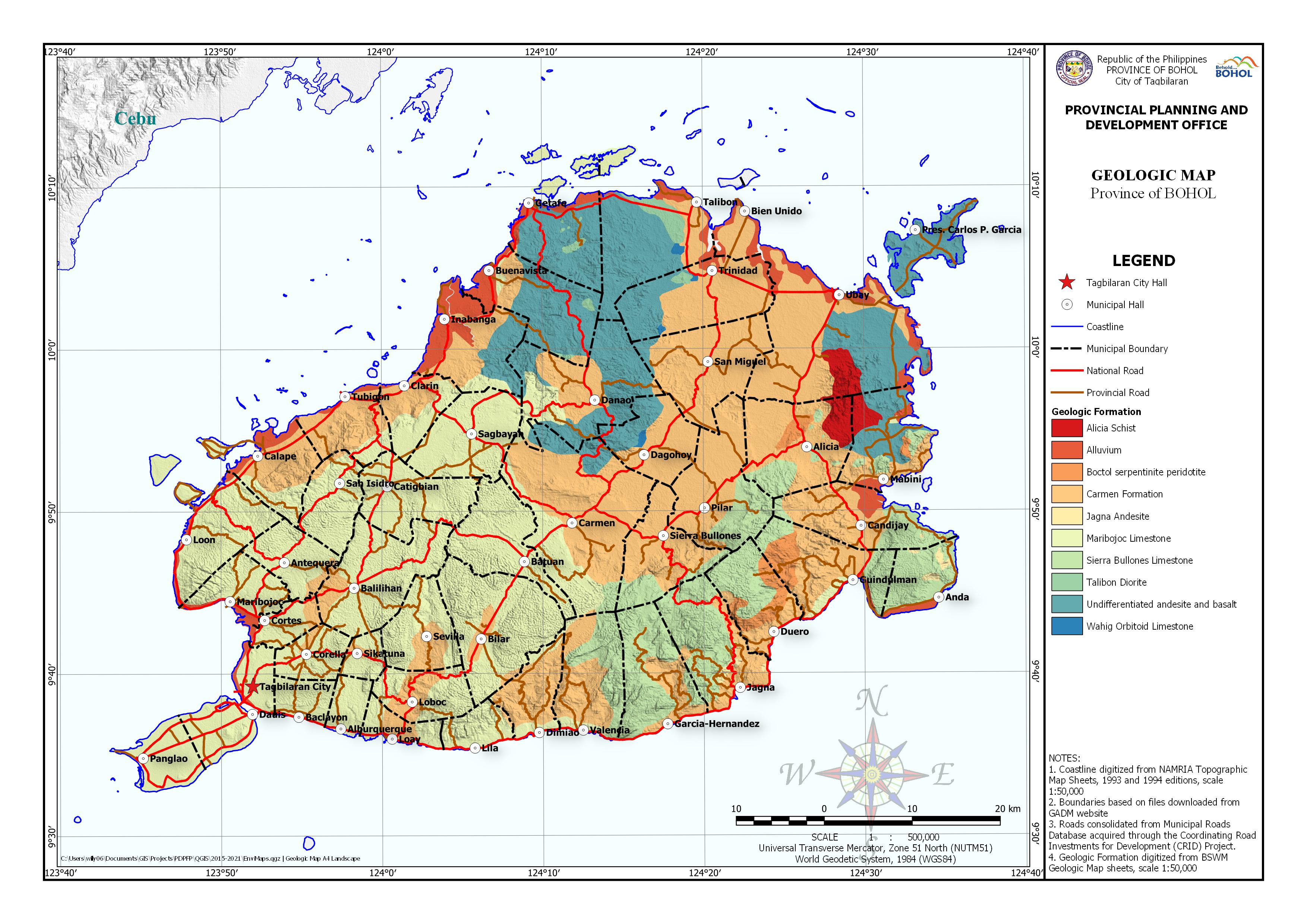
The Geologic Map shows areas of different geologic formation classification categories: Alicia Schist, Alluvium, Boctol Serpentinite Peridotite, Carmen Formation, Jagna Andesite, Maribojoc Limestone, Sierra Bullones Limestone, Talibon Diorite, Undifferentiated Andesite, and, Wahig Orbitoid Limestone. The Geologic features were digitized from the Geologic Map of the Bureau of Soil and Water Management. Base map features were digitized from the National Mapping and Resource Information Authority (NAMRIA) Topographic Map sheets scaled at 1:50,000 using heads-up digitizing method.
Available in PDF and JPG formats, this map may be downloaded and used for free provided that no alterations are made to the map and that proper citations be referred to this source.


To whom it may concern:
Kamusta po kayo diyan?
Isa po ako GIS Specialist sa Q.C. at nagtratrabaho sa isang NGO na Earthquakes and Megacities Initiative, Inc. Maglalabas po kami ng report na naglalaman ng mga impormasyon sa nangyaring lindol. Kadalasan ay galing sa internet. Isasama po namin ang ilan sa mga mapa sa inyong website. Meron po ba kayo standard citation?
Salamat po.
Hi Lalaine, you may just follow standards in citing websites.
To whom it may concern:
Good Day.
I’m a student at Negros Oriental State University, taking up Bachelor of Science in Geology. I would like to ask if it is possible that I could have a copy of a geologic map of the bohol for academic purposes. Hoping for a positive response. Thank you very much.
Hi June,
We have corrected the links to the PDF file of the Geologic Map, it is now available for download. You may also opt to download the JPG file, which is suitable for insertion in your documents. The PDF file is suitable for printing.
To whom it may concern:
Good Day.
I’m a student at the Technological Institute of the Philippines, taking up a Bachelor of Science in Architecture. I would like to ask if it is possible that I could have a copy of maps of the Bohol for academic purposes. Hoping for a positive response. Thank you very much.
Hi Francis, you may use the maps published on our website, wholly as it is. We appreciate proper citation of the data sources be carefully applied.
To whom it may concern;
Greetings!
I hope this message finds you well. My name is Eliza Mae Bijag, and I am currently conducting a special study as part of my academic research at Visayas State University-Main Campus, Department of Geodetic Engineering. My focus is on the geological features of Bohol, and I am particularly interested in obtaining vector data for geologic maps of the region.
Can I access any vector data geologic maps of Bohol that your organization may have? This data would greatly enhance my research and contribute to a deeper understanding of the area’s geological characteristics.
If available, I would appreciate any guidance on how to obtain this data, as well as any associated terms or conditions regarding its use for academic purposes.
Thank you for considering my request. I look forward to your response.
Warm regards,
Eliza Mae
Hi Ms. Eliza, we don’t have vector data for the whole of the region. However, there are a few Shapefile you can find here which we can share. Other files we have restrictions from the source.